
Precipitation detection over ocean using various radar remote sensing techniques have been fully understood and tested for several decades. But in terms of GNSS Reflectometry, researchers had been skeptical about its potential as a rain detector. Recently, a groundbreaking paper has been published by Dr. Milad Asgarimehr and his colleagues addressing this question cropping up in another paper published three years ago.
Having done his Ph.D. with Technische Universität Berlin, Berlin, Germany, Milad is currently doing his postdoctoral research on improving GNSS-R observations with AI at the German Research Centre for Geosciences (GFZ). Although the GNSS-R capability of rain detection had been doubted at the beginning, Milad’s recent study suggested that precipitation affects the power of reflected GNSS signals, which can be critical in GNSS-R experiments as we prefer to seek for unaffected data.
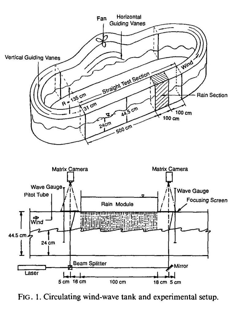
Regardless of microwave remote sensing, the effect of rain on ocean waves and currents has been simulated in laboratory experiments. As an example, this study designed a circulating wind-wave tank to simulate rain drops effects on ocean surface waves showing that ring waves caused by rain drops can amplify the surface roughness at centimetre scales although it can attenuate gravity waves over ocean surfaces. However, these laboratory studies could not fully explain the mechanism of rain effects on ocean surfaces in real environment.
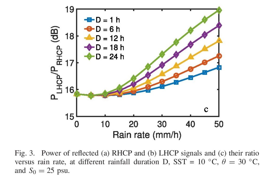
In this recent study, Milad tested the rain effect by analyzing polarimetric GNSS observation at a GFZ coastal GNSS-R station at Onsala Space Observatory in Sweden equipped with two side-looking antennas at two different polarizations (RHCP and LHCP). Among multiple results obtained from this experiment, including sea surface salinity changes due to rain events, the key one was discerning rain drops in the power of RHCP and LHCP reflections over a calm sea. Analyzing the I/Q components of the reflected signals, authors has shown that the received signal power at a low-wind-speed condition (<5 m/s) is reduced due to the diffuse scattering caused by rain-drop-made ring-waves over sea surface.

Reviewing this paper, I came up with this question if we could study ice bottom roughness using GNSS-R tools as either a ground-based or a satellite payload sensor. As discussed in a previous post, mid-winter warm temperature may cause changes in ice roughness, and this variation can be significant enough to be discerned by reflected GNSS signals. In addition, the water underneath the ice is so calm that satisfies the weak diffuse scattering regime condition, similar to the low-wind-speed condition Milad suggested in his paper. To see if GNSS-R has the potential to be used as a roughness indicator, the same steps can be taken as Milad has; however, a very big challenge is ahead of us in lake ice remote sensing: multi-layer scattering! In most GNSS-R studies, the reflection is assumed to be from a single reflective layer, e.g, sea water surface, but in lake ice, as shown in my master’s thesis, there are usually multiple reflective layers unless we experience consecutive days with a cold temperature so we can neglect undesired L-band reflections from layers rather than the ice-water interface.
To be specific, our Haliburton experience, which has been explained in Chapter 4 of my master’s thesis, clearly reflects the temperature effect in the power retrieval process (see this post). But aside from the temperature effect, Milad’s paper shows that GNSS-R is able to detect topography changes in small amplitudes. In other words, if the temperature is cold enough to avoid wet layers, ice bottom roughness may change the power of reflected signals as GNSS-R has well shown the potential to discern the rain-caused roughness in the order of ~5 to 50 mm. However, the other big challenge we may face is ancillary data about real ice bottom roughness, which seemingly necessitates another lengthy fieldwork. Dr. Grant Gunn has recently conducted a research on freshwater ice roughness and capacity (will be bulished by Jun 2021) summerizing multiple methods of ice roughness retrieval and explaining in-situ measurements they have done for this purpose in the Straits of Mackinac region of the Great Lakes between Michigan’s upper and lower peninsulas.
