GNSS antennas are designed to suppress the reflected signal before it reaches the antenna. However, some of the reflected signals interfere with the direct signal, leading to a multipath effect in the GNSS observations. Reflected signals are used in many remote sensing applications. The determination of sea level variations is also included in these applications.
Cansu Beşel, a researcher from Karadeniz Technical University, Department of Geomatics Engineering, Turkey, has recently published a paper determining the sea level variations along the Turkish Mediterranean coast using GNSS-R. For this purpose, the monitoring sea level was assessed by using the MERS station located in Erdemli, Mersin, on the Mediterranean coast of Turkey. In this paper, the dominant multipath frequency in the SNR data is derived with two methods presented: the Lomb-Scargle periodogram (LSP) and the LSP with the Moving Average (MA) filtering.
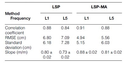
Time series of the sea level heights derived from LSP analysis can contain irregular variations. Thus, reasonable results cannot be generated for sea level heights. This study uses the moving average filtering method to eliminate these irregular variations. First, GNSS-R sea level heights were retrieved using the LSP method. Then, these results were used as input data in the MA filtering method and reconstruct the sea level heights. The GNSS-derived sea level observations were computed by the LSP and LSP with MA method and were compared with nearby tide gauge records. Figure below shows the comparison of GNSS-R retrievals and tide gauge records using LSP and LSP with MA method.

LSP with MA method indicated improvement in GNSS-R derived sea level, decreasing the RMSE and standard deviation. The results of the LSP and the LSP with MA method are presented in the table below. The GNSS-R-derived sea level observations and sea level records from a nearby tide gauge show similar trends. It should be noted that the performance of the SNR data at the MERS site could be improved with a higher sampling rate and different quality control metrics.